|
Coal and Coke Trail |
one moment while we fetch a trail picture
|
|
|
Coal and Coke Trail |
one moment while we fetch a trail picture
|
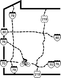
Trail map/brochure: westmorelandcountypa.gov/DocumentCenter/View/40/Coal-and-Coke-Trail-Brochure
USGS Topographic Maps: Mt Pleasant, Connellsville.
Coal and Coke Trail Chapter of the Regional Trail Corporation
PO Box 360
Scottdale, PA 15683
westmorelandcountypa.gov/1006/Coal-Coke-Trail
coalandcoketrail@yahoo.com